Why it's trending
Multiple regions face simultaneous severe weather threats: widespread damaging winds and flash flooding from the Midwest to the East Coast, plus a Level 1 risk in Alabama. The system's intensity and broad impact have drawn national attention.
A powerful storm system is poised to bring damaging winds, hail, and flash flooding to a large swath of the northern United States starting Sunday evening, with impacts expected to linger through midweek, according to forecasters. The National Weather Service has issued warnings for the Great Lakes and Ohio Valley, where wind gusts could reach 85 mph, while the Northeast and mid-Atlantic face similar threats along the I-95 corridor from New York City to Raleigh, North Carolina.
AccuWeather meteorologist Brandon Buckingham said the system will develop into 'wide swaths of damaging wind gusts' as it advances southeast, fueled by ample heat and humidity. The same storm on Saturday night lashed Sioux Falls, South Dakota, with 80-mph winds and gusts above 90 mph, causing widespread power outages. As the storm moves east, forecasters warn of felled tree limbs, power outages, and hazardous travel, particularly during Monday evening commutes.
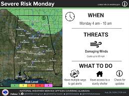
In the Southeast, Alabama is under a Level 1 severe weather risk for overnight hours, according to AL.com. The Alabama Weather Network reported a hot start to the week with scattered storms expected, with afternoon highs in the upper 90s to lower 100s across the central and southern US, according to the National Weather Service.
The storm system's northern periphery is expected to produce prolonged heavy rains through Tuesday evening, raising flash flood risks from Buffalo to Boston. By Wednesday, severe weather could threaten parts of New England, with urban areas and places with poor drainage particularly vulnerable. The combination of severe storms and extreme heat underscores a volatile weather pattern gripping much of the country.
Timeline
- Storm lashes Sioux Falls, South Dakota
80-90 mph winds cause widespread power outages, according to USA Today citing AccuWeather.
- Widespread thunderstorms develop over northern US
System expected to produce damaging winds up to 85 mph, hail, and heavy rain from Great Lakes to Ohio Valley, per AccuWeather.
- Storms threaten Midwest commutes
Damaging winds, lightning, and downpours expected; flash flooding possible. I-95 corridor from NYC to Raleigh at risk.
- Alabama Level 1 severe weather risk
AL.com reports a Level 1 risk added to overnight forecast for Alabama.
- Prolonged rains, flash flooding risk in Northeast
Heavy rains linger from Buffalo to Boston, raising flash flood concerns, per USA Today.
- Potential severe weather in New England
Flash floods possible in urban areas and places with poor drainage, per National Weather Service via USA Today.
Questions people ask
What areas are at highest risk for severe weather?
The Great Lakes and Ohio Valley face the greatest risk of damaging winds up to 85 mph. The I-95 corridor from New York City to Raleigh, NC, is also under threat, with flash flooding possible from Buffalo to Boston through Tuesday.
What is a Level 1 severe weather risk?
According to the National Weather Service's scale, Level 1 (Marginal Risk) means isolated severe thunderstorms are possible, with limited intensity and coverage. AL.com reported this risk for Alabama overnight.
How hot will it be in the South?
The National Weather Service forecasts afternoon highs in the upper 90s to lower 100s across central and southern US, with heat indices potentially exceeding those values, per USA Today and Alabama Weather Network.
Join the conversation 0
Comments are reviewed before publishing.